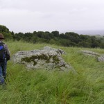
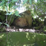
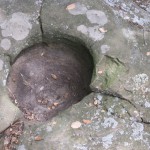
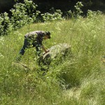
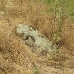
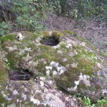
Garin Park, east spur
Garin Park, east spur2 bedrock mortars and possible grinding slick.This is on one of the principal routes to Walpert Ridge.One should secure permission before visiting this site.
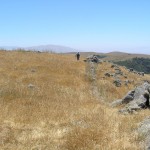
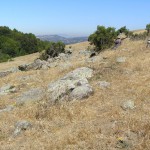
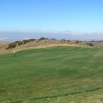
The Yrgin, an Ohlone tribelet, controlled the San Lorenzo Creek watershed on the east side of San Francisco Bay. Yrgin territory included the present day cities of Hayward and Castro Valley and extended from the bayshore to the heights of Walpert Ridge. Walpert Ridge gives every indication of being a religious/ceremonial center. Rock walls, rectangles, prayer circles, and other features are scattered across Walpert’s “high country.” We have no clue as to what, if anything, went on there, but we do know that Walpert Ridge possesses extensive views that encompass much of the central and south Bay Area. This is a place, like Mt. Diablo, where one can have the sense of being on top of the world, looking out over creation.
Some of the sites on Walpert Ridge are owned by the East Bay Regional Park District but held in “land bank” status. Others are on land held by private owners. One should secure permission before visiting any of them.
Randall Milliken suggests in A Time of Little Choice that the Yrgin and the Jalquin may have been the same people. He does not represent this possibility on his tribelet maps in Native American History Studies for the Los Vaqueros Project: A Synthesis, which we follow here.
Garin Park, east spur2 bedrock mortars and possible grinding slick.This is on one of the principal routes to Walpert Ridge.One should secure permission before visiting this site.
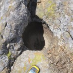
Upper Ukraina29 bedrock mortars at and around a creek confluence.Ukraina was the final and only safe home for Agapius Honcharenko, Ukrainian patriot and Greek Orthodox priest who was harassed by Tsarist police and special agents across Europe and America on account of his pro-Ukrainian and anti-Russian writings. That he found a safe haven on Walpert […]
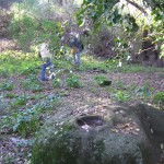
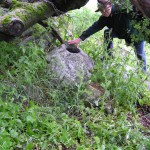
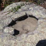
Garin, single mortar1 bedrock mortar next to the trail under a tree.Was this little camp a traveler’s rest stop?Bob’s right hand just about spans the mortar’s mouth.One should secure permission before visiting this site.
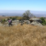
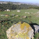
Walpert Ridge Lookout19 bedrock mortars.Many are worn and chipped, giving the apppearance of age.The lookout.The view north and east from here is as impressive as the one to the west. This hill can be identified from many locations in the East Bay.Looking toward Mission Peak. Note the stacked rock wall probably constructed in historic times.Two […]
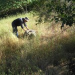
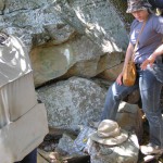
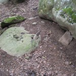
Gossip Rock5 bedrock mortars, possible cupules and incisions.This is one of the rare archaeological sites identified by East Bay Regional Parks. It’s listed right there on the map for Garin/Dry Creek Pioneer Park. Be sure to sit here for a while. Enjoy the south-facing rock and the view of Mission Peak.Jim studies a mortar on […]
Hill 14244 bedrock mortars, partial stacked rock rectangle, and other rock alignments.This site is named for its elevation, which is marked on the topographic map that covers Walpert Ridge.There’s a rockwall enclosure here, although it’s hard to make out in places. Perhaps some of it has been removed or buried.This prayer circle is nearby. Bob […]
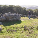
Jalquin Vista Park16 bedrock Mortars, many with recessed “Olla” rims3 housepitsElevation 1194 ft.What’s in a name? The City of Hayward may think this site was in Jalquin territory, but we believe the Yrgin controlled all of the Walpert Ridge “high country.”This is a great site with extensive views. You can drive right up to it.Note […]
Mid-Walpert Village32 bedrock mortars, rock wall alignments, numerous cupules and grinding slicks.A low, stacked-rock rectangle on a slope just below the crest of Walpert Ridge dominates this site. Could it have been a sheepherder’s corral? What, for paralyzed sheep? So who would have stacked these rocks if not the Yrgin residents of the small village […]
North Knoll, Chinese Tree of Heaven12 bedrock mortars, probable housepitsA crudely stacked rock wall protects a small campsite.One should secure permission before visiting this site.
North Walpert CampTwo probable bedrock mortarsElevation 785 ft.Another one of Jeff’s finds.A nearby spring furnished water for the inhabitants of this camp. There are impoundment ponds in the area today.A shallow bowl-shaped mortar.